
ملف:Titan 2009-01 ISS polar maps.jpg
الملف الأصلي (1٬884 × 942 بكسل حجم الملف: 510 كيلوبايت، نوع MIME: image/jpeg)
| هذا ملف من ويكيميديا كومنز. معلومات من صفحة وصفه مبينة في الأسفل. كومنز مستودع ملفات ميديا ذو رخصة حرة. |
ملخص
| الوصف |
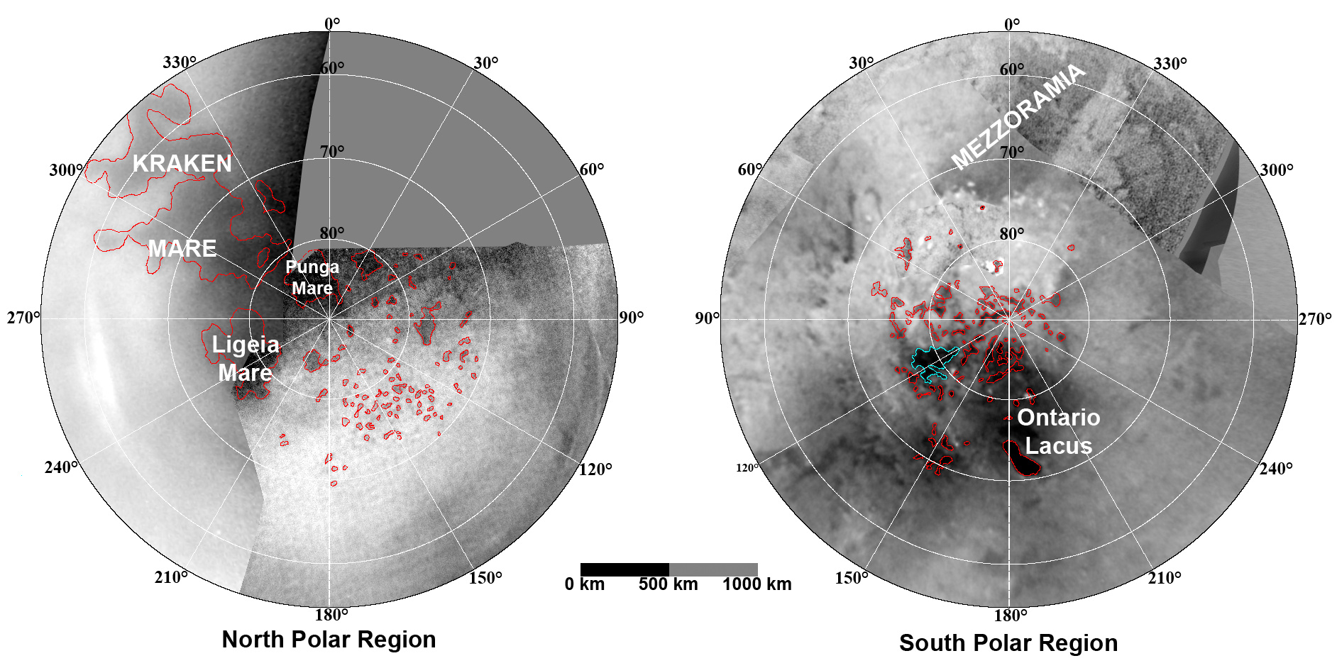
English: These updated maps of Saturn’s moon Titan, consisting of data from the Cassini Imaging Science Subsystem, include Cassini's August 2008 images of the moon's north polar region.
Evidence from Cassini's Imaging Science Subsystem, RADAR, and Visual and Infrared Mapping Spectrometer instruments strongly suggests that dark areas near the poles are lakes of liquid hydrocarbons like ethane or methane -- an analysis affirmed by images capturing changes in the lakes thought to be brought on by rainfall. Colored lines in the polar portions of these maps illustrate the boundaries between surface regions having different albedos -- or differences in surface brightness -- which Cassini scientists have interpreted as potential shorelines. Blue outlines indicate features that changed between observations made one year apart (see PIA11147). The map at left is a north polar projection showing latitudes 55 degrees to 90 degrees. The right map is a south polar projection showing latitudes minus qq55 degrees to minus 90 degrees. The maps are compiled from images dating from April 2004 through August 2008, and their resolutions vary from several hundred meters to a few tens of kilometers. Brightness variations are due to differences in surface albedo rather than topographic shading. The original NASA map of Titan has been cropped to show only the polar regions.Deutsch: Oberflächenkarte der beiden Pole, erstellt aus Daten des Cassini Imaging Science Subsystems, Januar 2009. |
| التاريخ | |
| المصدر | File:TitanMapJan2009.jpg, http://photojournal.jpl.nasa.gov/catalog/PIA11146 |
| المؤلف | NASA/JPL/Space Science Institute |
| إصدارات أخرى |
http://photojournal.jpl.nasa.gov/catalog/PIA11146
|

ترخيص
تحتوي هذه الصُّورة مواداً أنتجت بواسطة الإدارة الوطنيَّة للمحيطات والغلاف الجوي في الولايات المتَّحدة الأمريكيَّة. أُنشئت هذه المواد مِن قبل مُوظَّفٍ خلال أدائه لواجباته الرَّسميَّة أي أنَّها عملٌ من أعمال الحكومة الاتحاديَّة للولايات المتَّحدة، ولذلك فهي في النِّطاق العامِّ.
|
تاريخ الملف
اضغط على زمن/تاريخ لرؤية الملف كما بدا في هذا الزمن.
| زمن/تاريخ | صورة مصغرة | الأبعاد | مستخدم | تعليق | |
|---|---|---|---|---|---|
| حالي | 23:26، 7 أغسطس 2010 | | 1٬884 × 942 (510 كيلوبايت) | LobStoR | improved quality |
| 11:26، 31 يناير 2009 |  | 1٬884 × 944 (499 كيلوبايت) | WolfmanSF | {{Information |Description={{en|1=These updated maps of Saturn’s moon Titan, consisting of data from the Cassini Imaging Science Subsystem, include Cassini's August 2008 images of the moon's north polar region. Evidence from Cassini's Imaging Science S |
استخدام الملف
الصفحة التالية تستخدم هذا الملف:
الاستخدام العالمي للملف
الويكيات الأخرى التالية تستخدم هذا الملف:
- الاستخدام في an.wikipedia.org
- الاستخدام في be.wikipedia.org
- الاستخدام في de.wikipedia.org
- الاستخدام في en.wikipedia.org
- الاستخدام في en.wikiversity.org
- الاستخدام في fr.wikipedia.org
- الاستخدام في hy.wikipedia.org
- الاستخدام في id.wikipedia.org
- الاستخدام في ja.wikipedia.org
- الاستخدام في lb.wikipedia.org
- الاستخدام في mk.wikipedia.org
- الاستخدام في no.wikipedia.org
- الاستخدام في ro.wikipedia.org
- الاستخدام في ru.wikipedia.org
- الاستخدام في uk.wikipedia.org
- الاستخدام في vi.wikipedia.org
- الاستخدام في zh.wikipedia.org