
ملف:Mayotte, vue par Sentinel 2 (cropped).jpg

الملف الأصلي (4٬100 × 4٬381 بكسل حجم الملف: 11٫67 ميجابايت، نوع MIME: image/jpeg)
| هذا ملف من ويكيميديا كومنز. معلومات من صفحة وصفه مبينة في الأسفل. كومنز مستودع ملفات ميديا ذو رخصة حرة. |
ملخص
| الوصف |
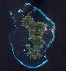
Français : L'ile de Mayotte dans l’océan indien vue par le satellite Sentinel 2, le 14 aout 2021.
English: Mayotte island (Indian Ocean) photographed by satellite Sentinel 2 on 14th August 2021. |
| التاريخ | |
| المصدر | https://phototheque.cnes.fr/cnes/media/68576 |
| المؤلف | European Space Agency / CNES |
| إصدارات أخرى |
_(cropped).jpg)

.jpg)
| موقع الكاميرا | | هذه وغيرها من الصور في مواقعها على: خريطة الشارع المفتوحة |
|---|
.jpg¶ms=-12.843056_N_0045.138333_E_globe:Earth_type:camera__&language=ar)
ترخيص

|
This image contains data from a satellite in the Copernicus Programme, such as Sentinel-1, Sentinel-2 or Sentinel-3. Attribution is required when using this image.
نسب العمل لمُؤَلِّفه: Contains modified Copernicus Sentinel data 2021
The use of Copernicus Sentinel Data is regulated under EU law (Commission Delegated Regulation (EU) No 1159/2013 and Regulation (EU) No 377/2014). Relevant excerpts:
Free access shall be given to GMES dedicated data [...] made available through GMES dissemination platforms [...].
Access to GMES dedicated data [...] shall be given for the purpose of the following use in so far as it is lawful:
GMES dedicated data [...] may be used worldwide without limitations in time.
GMES dedicated data and GMES service information are provided to users without any express or implied warranty, including as regards quality and suitability for any purpose. |

|
قُيِّمت هذه الصورة وفقاً لمعايير تقييم الصُّور، ونتيجةً لذلك، فإنها تعدُّ صورةً ذات قيمةٍ عاليةٍ في كُومِنز في نطاق: Mayotte island, France - satellite view.. يُمكن أيضاً مُراجعة صفحة ترشيح الصُّورة للتقييم. |
.jpg)
تاريخ الملف
اضغط على زمن/تاريخ لرؤية الملف كما بدا في هذا الزمن.
| زمن/تاريخ | صورة مصغرة | الأبعاد | مستخدم | تعليق | |
|---|---|---|---|---|---|
| حالي | 11:52، 17 فبراير 2022 | | 4٬100 × 4٬381 (11٫67 ميجابايت) | Don-vip | File:Mayotte, vue par Sentinel 2.jpg cropped 18 % horizontally, 12 % vertically using CropTool with lossless mode. |
استخدام الملف
الصفحة التالية تستخدم هذا الملف:
الاستخدام العالمي للملف
الويكيات الأخرى التالية تستخدم هذا الملف:
- الاستخدام في arz.wikipedia.org
- الاستخدام في ast.wikipedia.org
- الاستخدام في az.wikipedia.org
- الاستخدام في ca.wikipedia.org
- الاستخدام في ceb.wikipedia.org
- الاستخدام في ce.wikipedia.org
- الاستخدام في cy.wikipedia.org
- الاستخدام في de.wikivoyage.org
- الاستخدام في eo.wikipedia.org
- الاستخدام في es.wikipedia.org
- الاستخدام في fr.wikipedia.org
- الاستخدام في fr.wikinews.org
- الاستخدام في fr.wikivoyage.org
- الاستخدام في ga.wikipedia.org
- الاستخدام في gl.wikipedia.org
- الاستخدام في hy.wikipedia.org
- الاستخدام في ig.wikipedia.org
- الاستخدام في mg.wikipedia.org
- الاستخدام في no.wikipedia.org
- الاستخدام في oc.wikipedia.org
- الاستخدام في pl.wikipedia.org
- الاستخدام في ps.wikipedia.org
- الاستخدام في ru.wikinews.org
- الاستخدام في tl.wikipedia.org
- الاستخدام في tt.wikipedia.org
- الاستخدام في vi.wikipedia.org
- الاستخدام في www.wikidata.org
.jpg)