
ملف:Map of Knickebein transmitters.svg

حجم معاينة PNG لذلك الملف ذي الامتداد SVG: 527 × 599 بكسل. الأبعاد الأخرى: 211 × 240 بكسل | 422 × 480 بكسل | 676 × 768 بكسل | 901 × 1٬024 بكسل | 1٬802 × 2٬048 بكسل | 658 × 748 بكسل.
الملف الأصلي (ملف SVG، أبعاده 658 × 748 بكسل، حجم الملف: 112 كيلوبايت)
| هذا ملف من ويكيميديا كومنز. معلومات من صفحة وصفه مبينة في الأسفل. كومنز مستودع ملفات ميديا ذو رخصة حرة. |
ملخص
| الوصف |
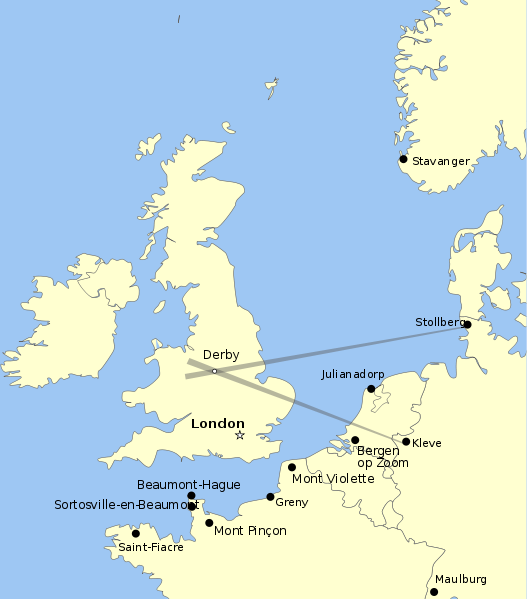
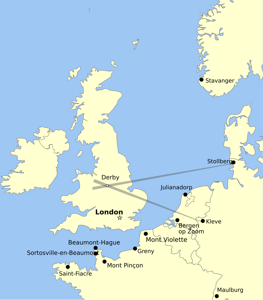
English: Map showing the positions of Knickebein transmitters during the battle of Britain. |
| التاريخ | |
| المصدر | عمل شخصي |
| المؤلف | Dahnielson |
ترخيص
أنا، صاحب حقوق التأليف والنشر لهذا العمل، أنشر هذا العمل تحت الرخص التالية:
هذا الملفُّ مُرخَّص بموجب رخصة المشاع الإبداعي نسبة المُصنَّف إِلى مُؤَلِّفه - المشاركة بالمثل 3.0 العامة
- يحقُّ لك:
- مشاركة العمل – نسخ العمل وتوزيعه وبثُّه
- إعادة إنتاج العمل – تعديل العمل
- حسب الشروط التالية:
- نسب العمل إلى مُؤَلِّفه – يلزم نسب العمل إلى مُؤَلِّفه بشكل مناسب وتوفير رابط للرخصة وتحديد ما إذا أجريت تغييرات. بالإمكان القيام بذلك بأية طريقة معقولة، ولكن ليس بأية طريقة تشير إلى أن المرخِّص يوافقك على الاستعمال.
- الإلزام بترخيص المُشتقات بالمثل – إذا أعدت إنتاج المواد أو غيرت فيها، فيلزم أن تنشر مساهماتك المُشتقَّة عن الأصل تحت ترخيص الأصل نفسه أو تحت ترخيص مُتوافِقٍ معه.

|
يسمح نسخ وتوزيع و/أو تعديل هذه الوثيقة تحت شروط رخصة جنو للوثائق الحرة، الإصدار 1.2 أو أي إصدار لاحق تنشره مؤسسة البرمجيات الحرة؛ دون أقسام ثابتة ودون نصوص أغلفة أمامية ودون نصوص أغلفة خلفية. نسخة من الرخصة تم تضمينها في القسم المسمى GNU Free Documentation License. |
لك أن تختار الرخصة التي تناسبك.
تاريخ الملف
اضغط على زمن/تاريخ لرؤية الملف كما بدا في هذا الزمن.
| زمن/تاريخ | صورة مصغرة | الأبعاد | مستخدم | تعليق | |
|---|---|---|---|---|---|
| حالي | 06:47، 26 أغسطس 2011 | | 658 × 748 (112 كيلوبايت) | Chriusha | Position of K 11 corrected, see Disk |
| 15:38، 13 مايو 2011 |  | 658 × 748 (112 كيلوبايت) | Hohum | More readable text. | |
| 22:18، 21 أبريل 2010 |  | 658 × 748 (113 كيلوبايت) | Dahnielson | Made the beams nicer, changed the Stollberg label and hopefully fixed the font rendering. Category:Radio navigation Category:Battle of Britain | |
| 22:14، 20 أبريل 2010 |  | 658 × 748 (114 كيلوبايت) | Dahnielson | Added Julianadorp and Bergen op Zoom to map | |
| 21:50، 20 أبريل 2010 |  | 658 × 748 (111 كيلوبايت) | Dahnielson | Added transmitter locations and the Kleve/Stollberg beams targeting Derby as an example. | |
| 19:19، 20 أبريل 2010 |  | 658 × 748 (103 كيلوبايت) | Dahnielson | Reverted to version as of 18:47, 20 April 2010 | |
| 19:18، 20 أبريل 2010 |  | 658 × 748 (103 كيلوبايت) | Dahnielson | Try to fix the font issue. | |
| 18:47، 20 أبريل 2010 |  | 658 × 748 (103 كيلوبايت) | Dahnielson | {{Information |Description={{en|1=Map showing the positions of Knickebein transmitters during the battle of Britain.}} |Source={{own}} |Author=Dahnielson |Date=2010-04-20 |Permission= |other_versions= }} |
استخدام الملف
الصفحة التالية تستخدم هذا الملف:
الاستخدام العالمي للملف
الويكيات الأخرى التالية تستخدم هذا الملف:
- الاستخدام في de.wikipedia.org
- الاستخدام في en.wikipedia.org
- الاستخدام في es.wikipedia.org
- الاستخدام في fr.wikipedia.org
- الاستخدام في he.wikipedia.org
- الاستخدام في sk.wikipedia.org