
ملف:Greater London boroughs 2009 map.svg

الملف الأصلي (ملف SVG، أبعاده 1٬425 × 1٬140 بكسل، حجم الملف: 761 كيلوبايت)
| هذا ملف من ويكيميديا كومنز. معلومات من صفحة وصفه مبينة في الأسفل. كومنز مستودع ملفات ميديا ذو رخصة حرة. |
ملخص
| الوصف |
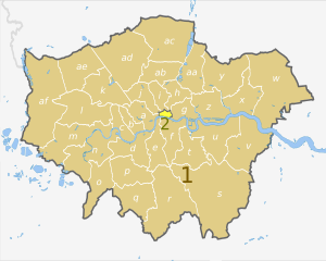
English: Map of Greater London, UK with districts shown, in the same style as other maps of English regions. The county colours are the same as those in File:English metropolitan and non-metropolitan counties 2009.svg.
Equirectangular map projection on WGS 84 datum, with N/S stretched 160%. Geographic limits:
|
| التاريخ | (UTC) |
| المصدر |
هذا الملفُّ مُشتقٌ مِن : Greater London UK district map (blank).svg: |
| المؤلف |
|
.svg)
| Map | Ceremonial county | London boroughs |
|---|---|---|
 |
1. Greater London |
a) City of Westminster, b) Kensington and Chelsea, c) Hammersmith and Fulham, d) Wandsworth, e) Lambeth, f) Southwark, g) Tower Hamlets, h) Hackney, i) Islington, j) Camden, k) Brent, l) Ealing, m) Hounslow, n) Richmond, o) Kingston upon Thames, p) Merton, q) Sutton, r) Croydon, s) Bromley, t) Lewisham, u) Greenwich, v) Bexley, w) Havering, x) Barking and Dagenham, y) Redbridge, z) Newham, aa) Waltham Forest, ab) Haringey, ac) Enfield, ad) Barnet, ae) Harrow, af) Hillingdon |
| 2. City of London | ||
| هذا رسمٌ مُعَدَّلٌ رقميَّاً من النسخة الأصليَّة. التعديلات هي: recoloured and labelled in same style as other English regional maps. يُمكن الاطلاع على النسخة الأصليَّة هنا: Greater London UK district map (blank).svg:
|
ترخيص
- يحقُّ لك:
- مشاركة العمل – نسخ العمل وتوزيعه وبثُّه
- إعادة إنتاج العمل – تعديل العمل
- حسب الشروط التالية:
- نسب العمل إلى مُؤَلِّفه – يلزم نسب العمل إلى مُؤَلِّفه بشكل مناسب وتوفير رابط للرخصة وتحديد ما إذا أجريت تغييرات. بالإمكان القيام بذلك بأية طريقة معقولة، ولكن ليس بأية طريقة تشير إلى أن المرخِّص يوافقك على الاستعمال.
- الإلزام بترخيص المُشتقات بالمثل – إذا أعدت إنتاج المواد أو غيرت فيها، فيلزم أن تنشر مساهماتك المُشتقَّة عن الأصل تحت ترخيص الأصل نفسه أو تحت ترخيص مُتوافِقٍ معه.
سجلُّ الرَّفع الأصيل
This image is a derivative work of the following images:
- File:Greater_London_UK_district_map_(blank).svg licensed with Cc-by-sa-3.0
- 2010-08-22T08:09:33Z Nilfanion 1425x1140 (1104179 Bytes) +inset, water colour tweak
- 2010-07-16T23:35:33Z Nilfanion 1425x1140 (738807 Bytes) {{Information |Description=Map of [[w:Greater London|Greater London]], UK with districts shown. Equirectangular map projection on WGS 84 datum, with N/S stretched 160% Geographic limits: *West: 0.57W *East: 0.37E *North: 51
Uploaded with derivativeFX
تاريخ الملف
اضغط على زمن/تاريخ لرؤية الملف كما بدا في هذا الزمن.
| زمن/تاريخ | صورة مصغرة | الأبعاد | مستخدم | تعليق | |
|---|---|---|---|---|---|
| حالي | 22:05، 2 مايو 2012 | | 1٬425 × 1٬140 (761 كيلوبايت) | Dr Greg | == {{int:filedesc}} == {{Information |Description={{en|Map of Greater London, UK with districts shown, in the same style as other maps of English regions. The county colours are the same as those in [[:File:English metropolitan and... |
استخدام الملف
الصفحة التالية تستخدم هذا الملف:
الاستخدام العالمي للملف
الويكيات الأخرى التالية تستخدم هذا الملف:
- الاستخدام في de.wikipedia.org
- الاستخدام في en.wikipedia.org
- الاستخدام في fr.wikipedia.org
- الاستخدام في pnb.wikipedia.org
- الاستخدام في th.wikipedia.org
- الاستخدام في ur.wikipedia.org
- الاستخدام في zh-yue.wikipedia.org