
ملف:Colonisation 1754.png

الملف الأصلي (1٬799 × 789 بكسل حجم الملف: 144 كيلوبايت، نوع MIME: image/png)
| هذا ملف من ويكيميديا كومنز. معلومات من صفحة وصفه مبينة في الأسفل. كومنز مستودع ملفات ميديا ذو رخصة حرة. |
| الوصف |
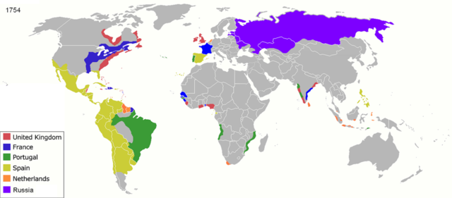
Map of major world powers by year, derived from public domain animated map on wikipedia.
As the orriginal licence of the animation was Public Domain, this image which has been derived from it is too:
|
||||||||||||||||||
| التاريخ | |||||||||||||||||||
| المصدر | public domain animated map by ArdadN here | ||||||||||||||||||
| المؤلف | ArdadN | ||||||||||||||||||
| إصدارات أخرى |
|
||||||||||||||||||

.jpg)
._LOC_2001620596.jpg)
تاريخ الملف
اضغط على زمن/تاريخ لرؤية الملف كما بدا في هذا الزمن.
| زمن/تاريخ | صورة مصغرة | الأبعاد | مستخدم | تعليق | |
|---|---|---|---|---|---|
| حالي | 23:55، 17 مارس 2022 | | 1٬799 × 789 (144 كيلوبايت) | M.Bitton | per https://commons.wikimedia.org/w/index.php?title=Commons:Graphic_Lab/Map_workshop&oldid=640501111#Wrong_borders |
| 12:27، 4 أكتوبر 2020 |  | 1٬799 × 789 (460 كيلوبايت) | Ориенталист | quality | |
| 09:30، 5 أبريل 2020 |  | 1٬200 × 526 (263 كيلوبايت) | Ориенталист | cosmetic changes | |
| 14:47، 27 مارس 2020 |  | 1٬799 × 789 (532 كيلوبايت) | Ориенталист | Clarified the territory of Russia. By 1754, the north of Siberia had already been explored | |
| 20:44، 2 نوفمبر 2017 |  | 1٬425 × 625 (71 كيلوبايت) | Alvin Lee | According to the Treaty of Nerchinsk in 1689, Outer Manchuria was the territory of China (Qing Dynasty), not Russia. Russia got Outer Manchuria after Treaty of Aigun of 1858. | |
| 20:30، 2 نوفمبر 2017 |  | 1٬425 × 625 (47 كيلوبايت) | Alvin Lee | I am changing the ancient boarder of Qing dynasty and Russia, not the modern boarder | |
| 15:35، 14 فبراير 2017 |  | 1٬425 × 625 (43 كيلوبايت) | Fentener van Vlissingen | Reverted to version as of 23:29, 27 June 2012 (UTC) that edit did not change the borders between Russia and China and re-added errors fixed in previous version | |
| 00:35، 3 أغسطس 2014 |  | 1٬425 × 625 (47 كيلوبايت) | Alvin Lee | Correcting the boundaries of Russia and China | |
| 23:29، 27 يونيو 2012 |  | 1٬425 × 625 (43 كيلوبايت) | Fentener van Vlissingen | There are still many things wrong with this map, but I corrected the most blatant errors: right shade of Orange for Demerara, Essequibo, Berbice, added Dutch Gold Coast, Dutch Malabar, Dutch Coromandel, Dutch Bengal. European presence in Africa and Ind... | |
| 21:27، 23 يناير 2011 |  | 1٬425 × 625 (66 كيلوبايت) | Micsha~commonswiki | Reverted to version as of 13:52, 29 April 2010 |
استخدام الملف
الصفحة التالية تستخدم هذا الملف:
الاستخدام العالمي للملف
الويكيات الأخرى التالية تستخدم هذا الملف:
- الاستخدام في als.wikipedia.org
- الاستخدام في ast.wikipedia.org
- الاستخدام في azb.wikipedia.org
- الاستخدام في bn.wikipedia.org
- الاستخدام في br.wikipedia.org
- الاستخدام في de.wikipedia.org
- الاستخدام في el.wikipedia.org
- الاستخدام في en.wikipedia.org
- الاستخدام في es.wikipedia.org
- الاستخدام في et.wikipedia.org
- الاستخدام في fr.wikipedia.org
- الاستخدام في ko.wikipedia.org
- الاستخدام في la.wikipedia.org
- الاستخدام في no.wikipedia.org
- الاستخدام في oc.wikipedia.org
- الاستخدام في pt.wikipedia.org
- الاستخدام في ro.wikipedia.org
- الاستخدام في sh.wikipedia.org
- الاستخدام في sw.wikipedia.org
- الاستخدام في te.wikipedia.org
- الاستخدام في uk.wikipedia.org